About the park

Our website relies on donations and affiliate links. If you click a link taking you to another website, and make a purchase, we may gain a small commission - at absolutely no cost to you. This helps us expand the website, so we can continue doing what we love!
Prior to becoming President of the United States, Theodore Roosevelt spent many years journeying between New York and North Dakota. He took a liking to the western lifestyle and the idea of becoming a cattle farmer, purchasing a ranch and expanding it, including building his Maltese cabin which still stands today. He then spent more time here following the tragic death of his wife and mother on the same day in 1884. The idea of influencing politics on a national level rather than state still enchanted him however. Following the death of much of his cattle from starvation in 1887, he made sure to include conservation policies when successfully becoming president in 1901. These policies where instrumental in the creation of the National Park Service as well as National Forests, putting 230 million acres under federal protection during his presidency.
The park is split into three units and rather uniquely, two time zones. Most visitors explore the south unit, being close to Medora, a cute, Western style town with shows including a musical that is a must watch for visitors! In the northern unit, an hours drive from the south, there's a 28 mile out and back scenic drive to Oxbow Overlook and numerous hikes in designated areas of wilderness. And in between lies Elkhorn ranch, built by Theodore Roosevelt. However, the unit is largely undeveloped, with no facilities, and requires a 4x4 to reach this secluded area of the park along a scenic road.
Can't miss
Wind Canyon
Located in the south unit, Wind Canyon is one of the best viewpoints in the park. The trail at the canyon is just a 0.3 mile loop, and is a perfect place to watch the sun set over the badlands. The Little Missouri river is the centrepiece of the overlook, on its way to joining the Missouri-Mississippi river, the longest river in the United States.

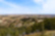
Scoria Point Overlook
Located in the south unit, Scoria Point offers another great view of Theodore Roosevelt NP. From here you can see the red layers of rock that make up the badlands, formed by the fusing and baking of sand, shale and clay. A great photo opportunity on the 36 mile scenic drive loop!

Wildlife spotting in the Badlands
No matter where you are in the north or south units, wildlife will never be too far away! Prairie dogs can often be seen scurrying around and calling to their friends to warn them if they see you. Meanwhile, bison, elk & wild horses roam the grassland areas. Remember to not get too close and disturb the animals, for their safety and yours!

Explore the park


Click to expand


Points of interest
Trails
As ever, we recommend conducting some of your own research on hikes as well as talking to park rangers in order to find less populated trails that may be of interest, helping prevent overcrowding and erosion of the park's best known routes. But here are a few suggestions to consider to get you started...

Gentle
Prairie Dog Town & Buckhorn trail
Caprock Coulee Trailhead, North Unit
Length (roundtrip): 1.5 miles
Approximate duration: 1 hour
Maximum elevation: 2050 ft
Max-Min elevation change: 100 ft
Starting very briefly on the Caprock Coulee trail, head onto the Buckhorn trail heading north to prairie dog town. The trail is largely flat and you'll know you're at the town when you hear plenty of screams & barks from the prairie dogs. Be sure to factor in some extra time to really enjoy watching these small but noisy creatures!
Along the way you may also spot other wildlife, including feral horses. These horses aren't native to the park but are a reminder of the ranching days of the land. Bison may also be spotted but as this is one of the more popular areas of the North Unit, they sometimes reside in the quieter areas of wilderness. As always, make sure to stay at least 25 yards away from animals - they can be unpredictable!

Moderate
Caprock Coulee Loop
Caprock Coulee Trailhead, North Unit
Length (roundtrip): 4.3 miles
Approximate duration: 2-3 hours
Maximum elevation: 2450 ft
Max-Min elevation change: 425 ft
The first three quarters of a mile are part of the Caprock Coulee nature trail, being relatively flat and providing some interesting flora and fauna which make up the prairie ecosystem, surprisingly one of the most diverse environments in the world!
After this, the trail becomes slightly more strenuous, climbing uphill around 400 ft to a ridgeline. From here ypu can see throughout the north unit, appreciating the beauty and scale of the badlands as you weave across the land on this ridge. It then descends back down, continuously providing opportunities to see bison and deer amongst areas of wildflowers. With good timing and preparation, you can see some of these views during sunset, where the national park really does look truly stunning.

Demanding
Lone Tree Loop
Peaceful Valley Ranch, South Unit
Length (roundtrip): 9.6 miles
Approximate duration: 4-6 hours
Maximum elevation: 2700 ft
Max-Min elevation change: 460 ft
Start off at Peaceful Valley Ranch, the only remaining original ranch house in the south unit. From here, travel either the Emblem trail or Lone Tree trail to the Little Missouri River. Cross the river provided the water level is relatively low and that it is safe to do so - depending on your equipment you could consider a quick change into a spare pair of shoes once reaching the other side for comfort.
For those looking to avoid a river crossing, you'll need to travel along the Maah Daah Hey trail from just off I-94, which adds a little more than 4 miles to the hike. Two other smaller river crossings will freshen you up as you cut through the Theodore Roosevelt wilderness, providing you with access to some of the south units most peaceful and quiet areas.
Where to stay
Hotel
picks

Rental
options

Campsite
choices
When to visit

We recommend:
June thru September - for warmer temperatures and accessible scenic roads through the parks units
Itineraries